1. Introduction
From the 1960s onwards, analogue cartography has been rapidly and comprehensively replaced. Geographic Information Systems (GIS) were progressively developed to capture, process, analyze, and map digital geodata 1. With the emergence of the interactive internet, digital geoinformation and cartographic representations are undergoing another fundamental transformation 2. This transformation is often labeled with the term ‘Geoweb’. The proliferation of global positioning systems in smartphones and navigational devices made the Geoweb part of mobile and daily practices. Alongside new commercial players, a growing number of ‘open’ Geoweb projects exist, with OpenStreetMap (OSM) being one of the most successful and prominent examples.
As a collaborative geodata project, OSM builds on a comprehensive software structure that differs to some extent from conventional GIS solutions. For instance, the data model does not include polygon features at all. While conventional data-models in GIS utilize point, line and polygon features for mapping geographic information, OSM consists solely of point and line features. Only with inconvenient workarounds and additional effort is it possible to map, render or work with polygon features.
Another example is the unconventional technology used for attributing geodata. Most governmental and commercial geodata providers use a comprehensive attribution system worked out by GIS experts. A well-known example of this kind of top-down and closed attribution system is the TIGER dataset of the United States Census Bureau 3. In comparison, OSM applies ‘folksonomies’, a tagging system which allows the OSM community to create freely any semantic annotations to classify online content – or in the case of OSM, geodata 4. In 2004, folksonomy – a term first introduced by Vander Wal 5 – was a new technology which spread rapidly on the internet. Haklay et al. described tagging as way of allowing “[…] users to create their own semantic categorization of online content” 6, a process which decentralizes the classification of content. Companies, such as Delicious or Flickr, provided website tools for tagging web content based on folksonomies 7. The usage of folksonomies became something like the zeitgeist of Web 2.0 at the time. However, among GIS experts, folksonomies were rather unknown.
In the context of OSM, folksonomies enable open and flexible attributing without any top-down or given rules. As a result, an ontology of OSM geodata rather evolves than being pre-defined. Furthermore, since users don’t have to learn an elaborate and pre-defined classification scheme first, folksonomies provide a simple access to the project and an easy way to contribute geodata. At the same time, due to their flexibility and lack of rules, folksonomies impede data integrity and thus clearly structured content 8. Taking a closer look at the example of folksonomies, it appears that this rather small part of the software structure in OSM significantly influences the overall project – to the extent that they constitute a key feature. Folksonomies are in use everywhere where the given structure of the data model is stretched to its limits. They provide an important framework for workarounds. For instance, the lack of a polygon feature was bypassed by tagging circled line features with a specific tag that marked the line as an area. Another example is the usage of folksonomies for adding metadata on geodata, such as comments about the editing process or notes about the editor in use. The technology of folksonomies enables specific routines, structures and content in OSM and complicates possible alternatives. In sum, the use of folksonomies in the context of geographic information is an exceptionally uncommon approach, while at the same time it constitutes an essential and meaningful technology to OSM.
Why is it that one of most successful Geoweb projects builds on such an unconventional attribution system? This paper analyzes the socio-technical background of software development in OSM through the example of folksonomies: we trace the origin of this meaningful technology back to its origin – the critical juncture in which the decision towards folksonomies was made – and address the nature of the decision and decision-making. In addition, we assess the preceding discussions, demonstrating technological alternatives, their advocates and relate them to their social implications. The ‘socio-technical’ in this approach is manifold: folksonomies themselves unfold social as well as technical consequences as they ensure a rather low entry barrier for OSM contributors, and at the same time make up a crucial element of the software structure; the decision towards folksonomies is socio-technical in the sense that a social ideal of decision-making – a bottom-up approach – was implemented in a technology; the preceding discussion is socio-technical, as the considered technologies were – to some extent – evaluated by their social implications.
The methodological approach is to perform a ‘digital archaeology’ in order to expose and record digital remains of this development process, aiming for a reconstruction of the evolution of software in OSM. This genealogy serves as an example for the purpose of understanding software as a social process of negotiation around ideas, arguments and personal interests. Thus, this paper contributes to the discussion of software studies as it puts the focus on the developmental process of impactful software sections in a social context.
Our findings suggest that there were three competing ideas in the project regarding the attribution system: a closed hierarchical and top-down administered classification scheme, which is a conventional approach with benefits for data maintenance; a bitwise scheme – an approach in which information for each object is stored in binary numerals – as a technical approach with benefits for the performance; and folksonomies as a bottom-up approach with advantages regarding obstacles for contributing to the project. An analysis of social dynamics during the early stages of the project reveals an increasing influence of one single actor as a major developer, code contributor and decision maker, as well as his central position in the overall communication. His central position in the project is also related to the decision towards folksonomies in OSM. This strong influence of a single contributor contrasts the do-ocratic decision-making in OSM – an allegedly open and inclusive organizational structure in which those who execute a task, get to decide how it’s executed. Furthermore, our data suggests that there are oligarchic structures in place, which – to some degree – conceal the general perception of do-ocratic inclusiveness and openness of decision-making in OSM.
This article is structured as follows: in the next section, we position our work in the context of previous research on OSM, with a focus on studies of community heterogeneity, content bias, and democratization effects. We then give an outline of our theoretical perspective by introducing concepts of software studies and Science and Technology Studies (STS). Then we describe our empirical approach to reveal the socio-technical background of software development in OSM. After presenting the results of the analysis, findings are discussed and connected to the current debate. Finally, the implications and limitations of this paper are presented.
2. Theoretical Background
2.1 Related Work on the Socio-Technical Background of OSM
OpenStreetMap describes itself as a “project that creates and distributes free geographic data for the world” 9: a project, designated to collect, edit, visualize and provide geodata. In addition, it is the most successful and prominent example of volunteered geographic information (VGI). This “free wiki world map” 10 builds on a web-based and collaborative platform which allows the community to contribute, use and download geodata. The contributors built the software architecture in a collaborative effort under an open license. Thus, software in OpenStreetMap does not only qualify as open-source software (OSS), also being developed in a non-commercial environment as a (for the most part) voluntary effort. OSM was founded in 2004; three years later, in 2007, all major technological decisions regarding the technological infrastructure were made (e.g. design of database, data-model or API). At the end of 2012, OSM reached one million users, and, in 2015, more than three billion nodes were entered in the database. Since then, the project has grown exponentially, with more than four billion nodes in the database, over four million registered users and more than 80 million edits per month (as of the end of 2017).
Today, OpenStreetMap is a very heterogeneous project. On the one hand, it serves as a basis for countless applications; there are maps for cyclists, hikers or public transportation networks, as well as routing services and location-based services. Each of these applications has specific characteristics and requirements regarding data content and data structure, shaping the project to this day. On the other hand, there are countless motivations and interests characterizing the contributor activity. Considering these countless applications, motivations and interests involved in OSM, it comes as no surprise that there is a large community participating in the project. In addition, OSM has found its way into mainstream media and everyday life, either through simple maps or sophisticated routing applications. Thus, OSM not only consists of a large database and software ecosystem, but also a growing community of users and developers.
However, the community in OSM is characterized by unequal participation. In their empirical analysis of contributor activity, Neis and Zipf 11 demonstrated the differing characteristics of the community using various criteria: number of contributions among specific member groups, member location, activity area, and activity time frame. In a similar study, Ma et al observed, “… a great heterogeneity of the OSM data and community” and, “… a clear power law distribution” 12, using head/tail breaks and power law statistics. Several other studies point in the same direction by referring to long tail distribution, power law distribution, or strong heterogeneity regarding user participation based on geodata contributions 13. Contributor activity and participation inequality in OSM is similar to other community-based projects such as Wikipedia, which often follow a 90–9–1 rule: 90% of the users observe/read the provided content, 9% of the users contribute now and then, and only 1% of the users are dedicated to the project, and contribute the majority of the content 14.
This unequal participation also leads, to some extent, to a biased collection of data. For example, a quantitative study by Quattrone et al. 15 described to what extent highly active users and casual users contributed on differing levels, identifying a bias in terms of where information is being mapped 16. Haklay 17 also reported on spatial bias based on socioeconomic factors. In addition, Quattrone et al. 18 demonstrated differences in mapping dynamics between urban and rural areas regarding data collection in OSM. In short, research on data bias concludes that OSM data is Western, or more specifically, Euro-centric, rich in detail in urban areas, and mainly contributed by well educated, affluent, young men with technical backgrounds 19.
These community characteristics contradict the notion of democratization, which is often associated with the rise of collaborative geodata projects such as OSM. Focusing on governance in the OSM community, Glasze and Perkins 20 described the decision-making process as a combination of democracy, meritocracy, technocracy and bureaucracy, emphasizing the simultaneity of these approaches. It is notable that this way of decision-making works in favor of contributors with technical skills—a deeper technical understanding does not only put you in a better position in a technocratic system, but is also beneficial for contributing extensively in a web-based crowdsourcing project. Haklay 21 argued that the democratization claims are strongly linked to the ability to alter digital systems. He draws on a critical philosophy of technology and especially on the work of Feenberg 22, who argues that influencing the project and thus reaching the full democratic potential of OSM is linearly dependent on the degree of technical knowledge and skills 23. In sum, both studies highlight the central role and disproportional influence of technical skills of contributors on OSM.
The importance of technical skills comes as no surprise, as software plays a crucial role in the project. In its essence, OSM is a digital platform and database with a large web-based software infrastructure. A great number of diverse software-applications are structuring the engagement with geodata. They enable many different forms and levels of involvement with the project. Accordingly, software itself is repeatedly referred to as a crucial element of OSM 24. In other words, the digital structure in OSM is a vital part of the project. It is inevitable to pass several software tiers in order to access or interact with geodata.
From the 1990s onwards, geospatial software has been a burgeoning subset of critical studies. This ongoing debate, labeled as critical GIS, focuses on the social construction of GIS as well as its social implications 25. For example, Harvey and Chrisman 26 argued against a linear logic of origins and heroic inventors by taking a historical perspective on the examination of GIS. Chrisman 27 stressed the importance of a full circle of implications: how the social influences GIS and how GIS influences the social. However, these studies remained heavily focussed on the research object of GIS as a special software for experts. In the following years, while cartographic representations and production transformed in the context of the interactive web, the Geoweb increasingly moved to the fore of critical research. For instance, Dodge and Kitchin 28 analyzed how the digital is entangled with our everyday spatialities. Haklay 29 focuses on the democratizing effects of collaborative geospatial software, yet, critical research on the Geoweb often focuses on the social implications of software 30. However, an essential exception is the work of Burns, in which he examines the knowledge politics of digital humanitarism on the case example of – inter alia – the Humanitarian OpenStreetMap Team (HOT). In his study, he assesses “[…] four distinct ‘moments of closure’ in which decisions were made that led to some epistemologies being accepted into digital humanitarian practices, and others written out” 31. Thus he seeks to understand how specific knowledge is “[…] made durable in the socio-technical practices and artifacts of digital humanitarism” 32 by addressing tagging issues, respectively categories, data quality criteria and issues of privacy, security and visibility. Despite providing valuable insights in these ‘moments of closure’, his study focuses more on technological settings rather than technologies themselves. What is still missing is a critical examination of software development in non-professional knowledge production – a profound analysis of the emergence of specific technologies in an environment which lacks of hierarchical structures and top-down decision-making processes common in conventional software companies. It is surprising that, despite the crucial role of software, the community-based software development in OSM never draws as much attention as the contribution processes for geodata regarding agenda setting, decision making or biased results. The research on the mapping community suggests that the developmental community might be heterogeneous as well. Furthermore, the collaboratively developed software is also affected by subjective opinions and decisions. All together, these observations raise the question: is software development a major under-researched factor within OSM? Throughout this paper, we examine the socio-technical background of one specific element of the software development in OSM: folksonomies.
2.2 Software Studies and Science and Technology Studies
The Science and Technology Studies (STS) provide a rich theoretical framework to analyze and understand the emergence of new technologies and innovations. They address the relation and links between the social and the technical and how they are negotiated: “[Machines and devices] form part of a long chain of people, products, tools, machines, money, and so forth” 33. From such a perspective, software development is always a result of negotiation processes. The involved social actors advocate their opinion and interests in the form of specific technologies, algorithms or code sequences. The result of such discussions is reflected in the software, a process often described as inscription. The inscription, a concept drawn from Actor Network Theory by Akrich 34, Callon 35 and Latour 36, is beneficial for a better understanding of the social impact on software. This study shares the understanding of technical objects being defined by their socio-technical relations as well as inscriptions being a process of translating roles, tasks, ideas or interests in software. While software is still often referred to as a neutral tool which is optimized for the best technical performance or usability, the inscriptions reveal the social character of software.
On the contrary to STS, software studies are closely related to media studies, originally focusing on software as new media, and thus its social and cultural effects. In his pioneering book “The language of new media”, Manovich 37 describes the characteristics of software and the nature of a computerized society. He distinguishes layers of new media through a ‘cultural layer’ and ‘computer layer’, emphasizing the cultural quality of software 38. Similarly, Fuller argues for a new form of criticism of software, asking: “What would happen if writers about computers expanded their horizons from the usual close focus on benchtests and bit-rates?” 39. In his understanding, criticism on software should also focus on software as a cultural object. But also, whether software should be object to cultural criticism.
Many scholars in geography sympathize with ideas of software studies since their field exhibits a rich history of reflecting the use of software in cartography, GIS and newer geospatial media 40. Burns and Lally highlight the materiality of software when they say that “[…] space is not just a container for software, but is actively produced by software in its various material, situated, and socio-technical contexts” 41. Similarly, Dodge and Kitchin – central authors in the field of ‘geographical software studies’, a label used by Burns and Lally – argued that “software is the product of a sociotechnical assemblage with knowledge, governmentality, practices, subjectivities, materialities, and the marketplace, embedded within contextual, ideological and philosophical frames, and it does diverse and contingent work in the world” 42. In other words, they argue that software is pervaded by all spheres of society and, at the same time, affecting and reshaping it.
In recent years, software studies have broadened its focus on software, including criticism on software production. Mackenzie stated already in 2006, that in order to understand “[…] what software does and how it performs, circulates, changes and solidifies cannot be understood apart from its constitution through and through as code” 43. Furthermore, he argues that “[…] the production of new media largely depends on the creation of software that remains largely invisible or somewhat infrastructural” 44. Thus, he exposes the problems of software production – a process which is often overlooked. More recently, Rieder 45 took a similar perspective when he focused on the PageRank algorithm and its historical roots, utilizing a software studies mind-set. Gehl and Bell 46 analysed software of large corporate actors and proposed a methodological framework, based on John Law’s concept of heterogeneous engineering 47 – an early concept in the field of STS – and Kirschenbaum’s challenge to software studies and its use of materialist methods 48. For scrutinizing the socio-technical background of folksonomies, we seek to build on these combined approaches of STS and software studies and address the software production of OSM.
The discussion of agency in software is an essential part of the software studies. According to Mackenzie 49, the possibility of attaching agency to software is elementary. Bucher 50 agrees, suggesting that software can be seen as having agency in the sense that it might affect the course of action of other agents. DV Berry, one of the pioneers in software studies, maintains that software provides a new way of delegating mental processes of high sophistication. He further argues that the main difference of inscriptions translated into software, rather than physical material, is that they are “mobile, quick, mutable (rather than immutable) and reflexively chang[ing] their own content (data)” 51. This agency-centric understanding implies that software “[…] enables or prevents certain things to happen” 52. Thus, the design of software is always affecting the interaction with it, resulting in facilitating some tasks and complicating others.
In summary, we relate to previous studies in the field of software studies addressing the creation of code and software, with an understanding of software being a cultural object; this mind-set highlights the effects and agency of software. Additionally, this understanding urges us to further investigate software development to reveal underlying negotiation processes and its socio-technical context. Here the perspective of STS is beneficial for addressing the imperfect and negotiated character of software. With personal ideas and opinions inscribed into technology it becomes necessary to understand how a specific idea or technology is selected. Thus, we approach the socio-technical background of folksonomies by analyzing the exchange of ideas and the subsequent decision-making processes.
3. Research Design and Methods
For understanding how roles, tasks or interests are inscribed in software, we seek to trace the establishment of folksonomies in OSM. The overall aim of the empirical work is to comprehend the emergence of this specific technology within its social context. We employed a social network analysis supplemented by in-depth archival reading; thus we combined quantitative and qualitative methods to enable a variety of angles for analyzing the development process in a critical and reflective way 53. The empirical work is based on three approaches. First, in order to understand the social context, we focus on the negotiation processes by analyzing the social position of central actors, respectively the advocates of specific technologies, by quantifying the communication dynamics of the mailing list. Second, we scrutinize the technological development, and consequently, changes in the source code, to be able to compare the discussion of technological solutions and their actual implementation. Third, we examine the content of relevant discussions regarding the attribution system in OSM – relevant in the sense that issues regarding the annotation of geodata were discussed. For each considered technology, we work out the perceived and connected ideas, concepts, and interests. Additionally, we outline the technical and functional context and origin of each technology.
Prior to the empirical work, we limited the relevant time period by focusing on the early years of OSM – until then, the technological orientation was still open. From the start of the mailing list in September 2004 until the end of 2005, the technological path of OSM was still an open question, as the first documented and structured API version (and therefore data model) appeared in March 2006. This time period was characterized by an intense discussion on a wide range of possibilities. As decisions towards specific software were yet to be made, no inscriptions were translated. By analyzing this time period, we aim to reveal the specific implementation work of folksonomies, as well as the social context, actors and negotiation processes related to this technology. In order to do so, we employ social analysis methods by utilizing a social network analysis. By taking the potential dynamics of networks into consideration, we divide the time period into three different slots. Originating from the start of the mailing list and the moment of decision towards folksonomies (March 2005), the first time slot includes the initial seven months (September 2004–March 2005). The second and third time slots each include the following three months (April 2005–June 2005, July 2005–September 2005). The social network analysis serves as an empirical basis in order to understand the group constellation of involved actors with their social position, their personal involvement in the project, and, therefore, their personal impact on decisions and developments in OSM. These time slots also serve as a structuring element for the analysis of code contributions to provide comparable results.
The social network analysis, as well as the examination of discussions, are based on the OSM mailing list. The mailing list in OSM plays a significant role in the overall communication of the project. As OSM is an international and digital project, face-to-face contact, at least on a daily basis, is practically impossible. The mailing list was established from the very beginning as the main communication medium, as the first mail was sent close to the founding date of OSM. Admittedly, there have been, and still are, other ways of communicating in OSM, such as the OSM forum, developer comment tools 54, the OSM-wiki 55 or personal meetings 56. However, some of these were not existent until mid-2006 (forum). Others included redundant information (OSM trac, wiki) or were documented within the mailing list (personal meeting, workshops). Furthermore, the mailing list produced relatively high traffic, as 113 different authors sent 2530 mails within the years 2004 and 2005 (16 months).
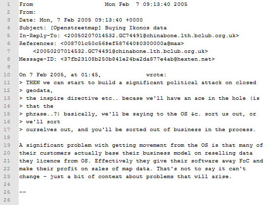
Emails in OSM are stored in an open web archive, accessible to research. The archive is encoded as plain text in the Mbox file format. A single message consists of a structured mail header, followed by the text body (Figure 1). The first line of the mail header contains summarized information about the message, such as the email address and send date/time. The following two lines provide some additional author and date information such as the username, or the time zone. Line 5 records which message-ID the mail replied to, and lines 6 and 7 specify cited mail text by their message-ID. Finally, the message-ID provides a unique identifier of the mail which is clearly relatable to a text body.
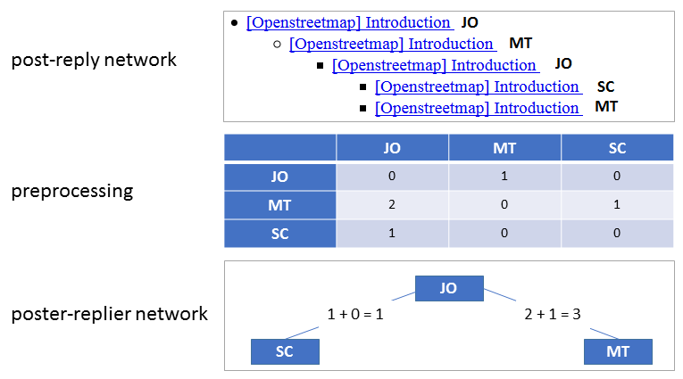
This study analyzes the mailing list with a communication-oriented modeling approach 57. This methodological framework moves the communication itself to the center of interest, rather than focusing on the agents of a network. As a result, the mailing list is structured as a poster/replier network. Figure 2 illustrates the network extraction process. Posts and replies often occur as a nested structure. In the example, a mail from MT replies to a mail from JO, which replies to another mail from MT, which in turn replies to an initial mail from JO. To avoid double counts, we restrict the analysis to direct replies. A preprocessing step determines for all mail addresses i and j the number n_ij of direct replies from i to messages of j. The nodes of the poster/replier network are the mail addresses. We have merged two addresses if the mail content or context indicates that the same individual has used them. An undirected edge exists between two distinct addresses i and j if n_ij>0 or n_ji>0. The weight associated with this edge is n_ij+n_ji. The undirected weighted edges express the fact that we are interested in the intensity of communication between addresses rather than in who initiated the chain of posts and replies.
The analysis of the poster-replier-network aims to understand which of the participants are especially active in the sense that they frequently communicate with many others. In the network, these actors are easily identified by their node degree. The degree centrality provides the conceptually simplest characterization of a network role: it best captures this kind of communicative activity. Other concepts of centrality seem less appropriate. Betweenness centrality, for instance, identifies actors who could potentially disrupt communication because of their control over passing information. In communication over a mailing list, however, the content of any message is immediately visible to all participants. Technical disruption of communication is not an issue in a poster-replier-network. Furthermore, a close reading of the mails reveals that discursive forms of disruptions such as “steamrolling” do not occur in the postings.
For the analysis of code contributions in OSM, we examine the code repository – the database in which all code contributions are stored. The project was developed with Apache Subversion (SVN), a software versioning and revision control system. The data is stored on a publicly accessible server, located at https://svn.openstreetmap.org. Each contribution from the past is traceable within this repository under a specific version number. This enables the quantification of code revisions of the contributors, as well as verification of the actual changes and implementations in the code. The analysis of code contributions serves as a complementary source and validation for results from the other empirical approaches.
Information on the identity of involved persons is available in the metadata of the mailing list as well as in the SVN. There should not be any concerns regarding privacy issues. Furthermore, we believe that in the context of software development, there is a sufficient level of technological knowledge and skills needed to understand the consequences of online contributions; the partial disclosure of one’s identity. However, no clear names are used in our further analysis and acronyms are used for assuring data privacy and a clear assignment of persons in the different sections.
4. Results
4.1 Communication Dynamics
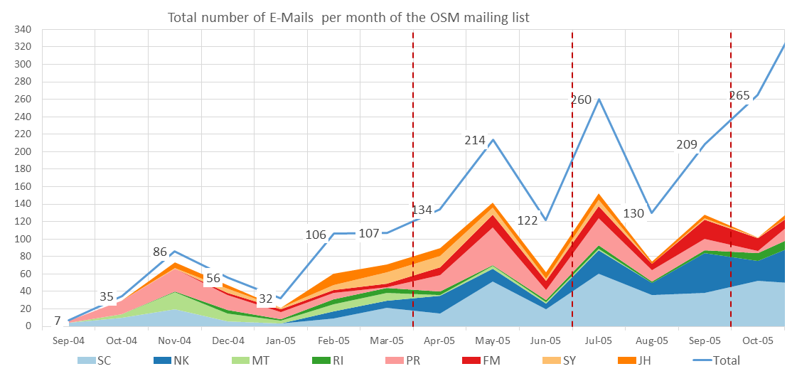
Figure 3 shows the accumulated number of mails per month in the mailing list. The first time slot comprises a total number of 429 mails from 38 different users, the second slot 470 mails from 42 different users, and the third slot 599 mails from 43 different users. There is a steady increase in the number of mails, although the number of involved users stays almost on the same level. Additionally, virtually throughout the complete time period, eight highly active users contributed approximately two-thirds of the total number of messages. This data suggests a high involvement in communication by a subgroup of users in the mailing list.
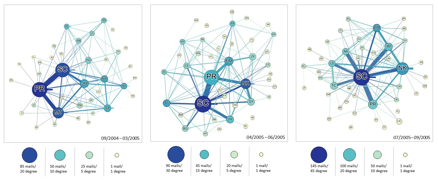
The network visualizations based on degree centrality reveal the importance of one small subgroup in the mailing list (Figure 4). It is characterized by a high number of emails sent, by strong ties between them, and a high degree of centrality. No other significant group emerges over time. In the first time slot, in which the decision towards folksonomies was made, there was an inner circle of users with SC, PR, and MT as the core of this group, dominating the communication not only with their total number of mails, but also by the number of contacted users. During the following period, NK and FM joined the nucleus. It is notable that PR was as active as SC regarding the number of mails, but seems to be less networked to other users on the mailing list. In the last period, there is a clear pattern emerging, in which SC is the most active and networked participant of the mailing list, while other participants became less important. To summarize, there is one inner circle of highly active and networked users over all time periods, remaining in the same composition for the most part.
4.2 Code Contributions
At the end of March 2005, there were significant changes of the data structure in OSM. SC added several functions to the osmServerHandler.java script, which were related to the implementation of folksonomies. Among these changes were several functions concerning the handling of key values pairs; these functions are necessary for the handling of an open classification scheme. Due to the SVN, these changes can be clearly assigned to SC. Thus, there is proof that folksonomies were implemented by SC at the end of March 2005.
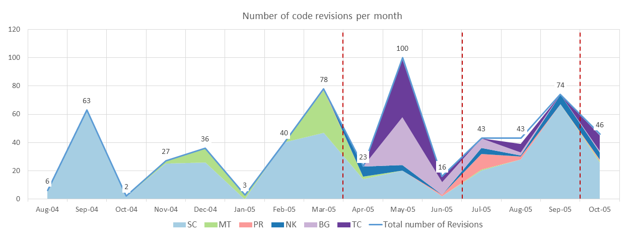
Figure 5 shows the accumulated number of revisions per month in the code repository. It is striking how few contributors were involved in the software development, especially when considering the number participants on the mailing list. Over the three time periods, and despite their small number, the composition of contributors and individual number of revisions varied widely. There were three contributors with a total number of 255 revisions in the first period, seven contributors with 139 revisions in the second period, and eight contributors with 160 revisions in the third period. Looking at the contribution dynamics of code in OSM, it becomes clear that until April 2005 most of the contributions were made by SC (from August 2004 to March 2005, approximately 82%), and a smaller but significant part by MT (approximately 18%). This period includes the decision towards and implementation of folksonomies in OSM. In contrast, the following time periods show a more diversified contribution, although SC still appears to be the most active developer (from April 2005 to September 2005, approximately 50%). Overall, Figure 5 presents three major results: first, there is only a particularly small number of contributors involved in the software development – even smaller than the inner circle of the mailing list. More specifically, there was a group of six persons who contributed the clear majority of revisions. Second, SC contributed a particularly large part of the revisions, especially in the first time period in which SC implemented folksonomies in OSM. Third, despite the large share of SC’s contributions, SC was not the only main code contributor throughout all time periods. These results are in line with the impressions of other central actors in this period 58.
4.3 Central Lines of Discussion
The discussions regarding the attribution system can be narrowed down to four subjects in the mailing list in which most ideas appeared and were discussed:
‘Map formats?’59
Participating users: SC, PR
‘street level ontology’ 60
Participating users: JH, MT, SC
‘openstreetmap.org updates, ontology stuff’ 61
Participating users: DV, JH, MT, NK, PL, SC
‘ontology, money’ 62
Participating users: DY, DV, HG, JH, MT, NK, SL, SY
Looking at the participation in the discussion concerning the attribution system, it becomes apparent that SC, MT and JH were extensively involved. Additionally, NK and DV appeared in more than one subject. The repeated appearances of MT and JH are notable, as they are far less active and networked than SC. Furthermore, their importance within the communication decreases after the decision towards folksonomy in March 2005. This data suggests that, next to SC, MT and JH are exceptionally dedicated to the discussion concerning an attribution system in OSM. However, as the previous data about the social positions in the mailing list and the code revisions showed, they take a weak position within the overall communication and they contributed a minor share in the developmental process.
Regarding the content of the discussions, it was JH who brought up the first idea for an attribution system: the TIGER definitions 63, which are a hierarchical and top-down administered approach. This is a conventional GIS approach, which was very common for professional handling of geodata: it builds on existing GIS ontologies, created by geospatial professionals. It was no surprise that JH came up with this idea: to that point, JH was the only person of the inner circle who did some profound research about existing conventions of handling geodata 64. JH considered this idea as well as the idea of a self-made closed attribution system, optimized for the needs of OSM. However, their suggestions were criticized by SC: “As for the TIGER definitions, I got the impression they were evolved rather than designed and an’t necessarily [sic] the way to go… is that the case?”(SC 17 November 2004 65). JH also considered other existing conventional standards for geographic information such as ISO 19000, ISO TC 211 General Features Model, or GML standards; all connected to hierarchical and closed attribution systems. She admitted that these standards are ‘over-engineered’ 66 and that they should look for the simplest useful thing – a term often used by the inner circle. This is an understanding in which the simplest technological solution should be implemented.
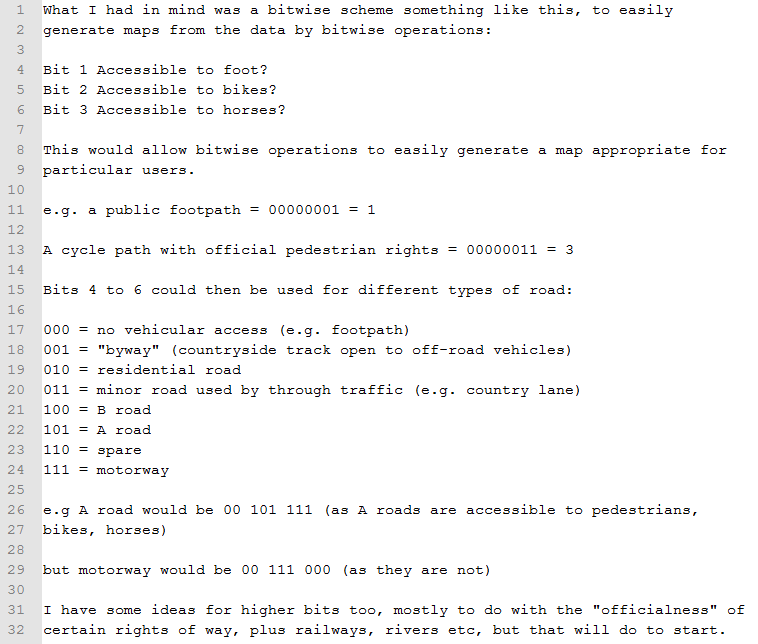
A technical approach was the idea of a bitwise scheme, brought up by NK. NK had their own map-project and was experienced in the technical difficulties of handling geodata and building a web-based map. Figure 6 illustrates how NK imagined a bitwise scheme: in an 8-bit format – with 8 binary numerals – and each position representing a specific attribute. In their example, the first binary numerals capture the accessibility of a road to pedestrians; the second position captures the accessibility for bikes. By suggesting a bitwise scheme, NK focused on the performance and the technical infrastructure of the map service. NK emphasized the advantages regarding the performance as one can easily generate maps (NK 19 March 2005 67). The bitwise scheme was also pushed by MT 68, though in a more human readable version. NK gave further examples of how a bitwise scheme could appear (Figure 6).
Looking at the discussion, it becomes clear that folksonomies were not considered as an attribution system for a long time. At least not until SC encountered the topic in the form of a transcribed conference session with Clay Shirky, Stewart Butterfield, Joshua Schachter and Jimmy Wales 69. In this session, the participants discussed the pros and cons of folksonomies. SC became so convinced about folksonomies as an attribution system, that he introduced this topic to the inner circle. Based on the discussion on the mailing list, it seems that he unilaterally brushed aside any other ideas and directly implemented folksonomies. SC noted: “I find ontologies incredibly dull and top-down. The latter is actually important since top-down stuff is so 1982 what with so many folksonomies (eg flickr, gmail, del.icio.us ) working well” (SC 18 March 2005 70). In the same e-mail, SC informed the other contributors that he had already chosen folksonomies as the attribution system for OSM: “This stuff is half-implemented, thought I’d open it up to y’all”. Within the inner circle, their decision towards folksonomies was never really questioned or criticized, as he was in a special position in OSM. With this move, SC clearly enforced their interest and idea of annotating geodata. There was neither a vote among the contributors or even the inner circle, nor was consensus reached. Rather, an announcement of a decision was made elsewhere, not on the mailing list – although the mailing list was the communication platform which was intended for discussion and coordination.
In 2015, SC argues retrospectively that he received negative reactions in the broader arena of OSM, which were not documented in the mailing list: “[…] pretty much everyone I showed it to was pretty universally negative, saying it would fail for some key reasons: either it didn’t have an ontology, or it would never be accurate enough, or you would never get enough volunteers” 71. As we could not find any evidence of criticism in the mailing list, this statement must be interpreted with caution. It is possible that the criticism was made in personal conversations or by persons outside the inner circle of contributors. Even though folksonomies in OSM were criticized, it had no impact on the decision as folksonomies are still the attribution system in use.
4. Discussion
Summarizing the technological approaches discussed, each of them had specific social implications. The conventional approach, brought up by JH, is a hierarchical, top-down and closed attribution system, which implies several consequences regarding the distribution of agency. It seems probable that an elite within the project would have organized, administered and managed all semantic categories by which geodata is annotated. As for the development of the software, the elite would most likely have originated of the inner circle. As a result, the inscription of this attribution system bears an uneven distribution of agency towards a small group of project leaders. The implementation of a bitwise scheme is beneficial, especially from a technical perspective. However, because of its lack of usability as a rather non-human readable scheme, a great technical expertise is necessary to handle these semantics. Organizing, administering and managing these semantic categories predominately remains reserved for technically experienced users. Thus, regarding the distribution of agency, an inscription of a bitwise scheme favors technically experienced users. The idea of utilizing folksonomies implies another inscription: the idea of a non-hierarchical, collaborative and bottom-up approach for annotating geodata. In other words, it enables the community to design, organize, administer and manage all semantic categories on their own, without interference from, for example, central project administrators.
Regarding decision-making in the software development process, the data indicates two distinct but complementary results. First, based on the communication dynamics and the content of discussions, it seems that decision-making is not based on the mailing list. However, despite the irrelevance of discussions on the mailing list for decision-making, the inner circle of contributors appeared intent on participating in them. This is surprising since the inner circle could easily coordinate such discussions themselves in private chats (IRC) or direct mails – without interacting or being interfered by the wider community. Instead, we would argue that the mailing list is a platform for discussing ideas, explaining implementations and thus legitimizing decisions that were made elsewhere. This legitimizing role, however, seems essential for a collaborative project to build transparency and to involve other contributors. In addition, the social network analysis reveals that the mailing list reflects, to some degree, the involvement of actors in the project and the software development. The second result, based on the SVN, suggests that the decision towards folksonomies is strongly related to code contributions. Decision making in the software development process of OSM can be referred to as ‘do-ocracy’, an organizational structure where the responsibility of decisions is attached to people who do the work, rather than officially elected or selected members of the community 72. However, since only few members have the technical skills and understanding of carrying out software changes, there is only a small elite group of contributors which are dominating the software development in OSM 73. Thus, decisions were made in a de-facto oligarchic environment, and in some cases – like in the example of folksonomies – in an unilateral decision.
Taking both results together, it appears that the communication on the mailing list conceals the de-facto oligarchic environment of decision-making: contributors without the necessary technical skills for participating in the software development are allegedly able to get involved in discussions regarding the technological orientation of OSM; they can discuss with the inner circle on the same communication platform, meeting them as peers. This impression of equality and involvement is facilitated by the high level of participation of the inner circle on the mailing list. However, our analysis revealed that decisions related to technological orientation were made – to a large extent – independently from discussions on the mailing list and in some cases even independently from the opinions of the inner circle. In the end, all technological decisions are made by those who carry out the software development, sometimes in accordance with other central actors. But, since all actors are devoted to do-ocracy, each decision is legitimized and fully accepted on the sole basis that an individual took the initiative and implemented a feature.
In summary, the findings support the idea of SC being a central actor of software development in this early stage of OSM, as he is strongly linked to the decision regarding the introduction of folksonomies. One may argue that it is an ironic twist that the inscription of this collaborative approach was determined by a unilateral decision.
Regarding the discrepancies in participation, our empirical sources reveal a similar picture to further studies relating to geodata contributions. Both communication and code contributions are heavily imbalanced regarding the number of contributors involved, although the level of imbalance differs. Code contributions may have a larger impact on the overall project, as they influence the future mapping project heavily. These results support the idea of 90–9–1 patterns in collaborative projects. However, it is important to bear in mind that we worked with a small sample size, based on 13 months of discussing and developing in OSM.
Folksonomies have unfolded further socio-technical consequences in subsequent years, as they emerged as an essential part of the overall software infrastructure in OSM. They proved to be a flexible and open classification scheme. OSM beginners do not necessarily need to learn elaborated classifications systems, which were designed in a top-down process. It is still possible to freely apply new tags. As local contributors often know which tags fit best for an object in their nearby environment, folksonomies provide a framework for bridging regional differences. Additionally, it is their flexibility which provides the technical possibility to channel the creativity of the community, such as creating workarounds. Conversely, adverse consequences of the OSM folksonomies relate to incoherent and partially chaotic annotations. As there is no closed classification system with strict rules, contributors may use quite different tags for comparable objects. Additionally, much effort is needed to use this geodata through rendering or routing software. In summary, the technology of folksonomies enabled the community to design, organize, administer, and manage all semantic categories; along with all the advantages and disadvantages. Beyond their original purpose, the flexibility of folksonomies allows technical adjustments and enhancements at a grassroots level. Though by this time, a structured majority voting procedure evolved, of which the community may adopt proposals on formalizing tagging schemes. However, the current practice shows that only a tiny minority of the community participates in such votes (it is common that only around ten contributors discuss and vote on proposals). In addition, formalizing a scheme does not mean that the community actually adopts it and starts mapping such geodata.
5. Conclusion
In this paper, we have focused on a distinct section of the software architecture in OSM to analyze its emergence in a socio-technical context. For this purpose, we performed an archaeological reconstruction of the development of folksonomies. By going back in time, we showed that the implementation of the technology becomes an inscription of a specific idea.
In conclusion, the finding that SC took a central role in the development process of OSM is not very surprising. However, it is not our intention to examine who did what in the developmental process. Essentially, we argue that the decisions towards specific forms of software play an important role for the further development of open and community-based projects such as OSM. Therefore, it seems necessary to better understand the socio-technical background of decisions for specific characteristics of software. By analyzing the development towards specific forms of software, it is possible to reveal specific ideas behind software, mechanisms of decision-making, participation inequality, and further social implications. Thus, we can build a better understanding of the origin and consequences of specific technologies for open geodata.
Acknowledgments
We acknowledge support by the Hanns-Seidel-Stiftung.
Conflicts of Interest
The authors declare no conflict of interest.
References
Akrich, Madeleine. 1997. “The De-Scription of Technical Objects.” In Shaping Technology/building Society: Studies in Sociotechnical Change, edited by Wiebe E. Bijker and John Law. [Nachdr.], 205–24. Inside technology 1. Cambridge, MA, London, England: The MIT Press; MIT Press.
Ali, Ahmed, Nuttha Sirilertworakul, Alexander Zipf, and Amin Mobasheri. 2016. “Guided Classification System for Conceptual Overlapping Classes in OpenStreetMap.” IJGI 5 (6): 87. doi:10.3390/ijgi5060087.
Arsanjani, Jamal J., Alexander Zipf, Peter Mooney, and Marco Helbich. 2015. “An Introduction to OpenStreetMap in Geographic Information Science: Experiences, Research and Applications.” In OpenStreetMap in GIScience: Experiences, Research, and Applications, edited by Jamal J. Arsanjani, Alexander Zipf, Peter Mooney, and Marco Helbich, 1–15. Lecture notes in geoinformation and cartography. Cham: Springer International Publishing.
Ash, James, Rob Kitchin, and Agnieszka Leszczynski. 2015. “Digital turn, digital geography?” The Programmable City Working Paper 17. Unpublished manuscript, last modified January 26, 2016.
Berry, David M. [2011] 2015. The Philosophy of Software. 2nd ed. Hampshire: Palgrave Macmillan. Code and Mediation in the Digital Age.
Bittner, Christian. 2017. “Diversity in volunteered geographic information: Comparing OpenStreetMap and Wikimapia in Jerusalem.” GJ 82 (5): 887–906. doi:10.1007/s10708-016-9721-3.
Bittner, Christian, Georg Glasze, and Cate Turk. 2013. “Tracing Contingencies: Analyzing the Political in Assemblages of Web 2.0 Cartographies.” GeoJournal 78 (6): 935–48. Accessed March 12, 2014.
Bucher, Taina. 2012. “Programmed Sociality: A Software Studies Perspective on Social Networking Sites.” Dissertation.
Budhathoki, Nama R. 2010. “Participant’s Motivations to Contribute Geographic Information in an Online Community.” Dissertation, University of Illinois at Urbana-Champaign. Accessed June 06, 2013.
Burns, Ryan. 2014. “Moments of closure in the knowledge politics of digital humanitarianism.” Geoforum 53:51–62. doi:10.1016/j.geoforum.2014.02.002.
Burns, Ryan, and Nick Lally. 2017. “Special Section Editorial: Toward a Geographical Software Studies.” Computational Culture 6.
Callon, Michel. 1991. “Techno-economic networks and irreversibility.” In A Sociology of monsters: Essays on power, technology, and domination, edited by John Law, 132–64. Sociological review monograph 38. London, New York: Routledge.
Chrisman, Nicholas. 1998. “Academic Origins of GIS.” In The History of Geographic Information Systems: Perspectives from the Pioneers, edited by T. Foresman, 33–44.
———. 2005. “Full Circle: More Than Just Social Implications of GIS.” Cartographica 40 (4): 23–35.
Coast, Steve. 2015. The Book of OSM. [Denver, Colorado]: Steve Coast.
Community Wiki. “DoOcracy.” https://communitywiki.org/de/DoOcracy.
Cope, Meghan, and Sarah Elwood, eds. 2009. Qualitative GIS a mixed methods approach. London.
Davidovic, Nikola, Peter Mooney, Leonid Stoimenov, and Marco Minghini. 2016. “Tagging in Volunteered Geographic Information: An Analysis of Tagging Practices for Cities and Urban Regions in OpenStreetMap.” IJGI 5 (12): 232. doi:10.3390/ijgi5120232.
Doctorow, Cory. 2005. “Folksonomy, or How I Learned to Stop Worrying and Love the Mess: Transcript of Emerging Technology Conference.” http://craphound.com/etech2005-folksonomy.txt.
Dodge, Martin, and Rob Kitchin. 2013. “Crowdsourced Cartography: Mapping Experience and Knowledge.” Environ. Plann. A 45 (1): 19–36.
Elwood, Sarah. 2010. “Mixed Methods: Thinking, Doing, and Asking in Multiple Ways.” In The SAGE Handbook of Qualitative Geography, edited by Dydia DeLyser, 94–113. Los Angeles, London: Sage.
Feenberg, Andrew. 1999. Questioning Technology. London, New York: Routledge. http://search.ebscohost.com/login.aspx?direct=true&scope=site&db=nlebk&db=nlabk&AN=60639.
———. 2002. Transforming Technology: A Critical Theory Revisited. 2nd ed. Oxford: Oxford University Press USA.
Fuller, Matthew. 2003. Behind the blip: Software as culture. New York: Autonomedia.
Gehl, Robert W., and Sarah A. Bell. 2012. “Heterogeneous software engineering: Garmisch 1968, Microsoft Vista, and a methodology for software studies.” Computational Culture 2.
Glasze, Georg, and Chris Perkins. 2015. “Social and Political Dimensions of the OpenStreetMap Project: Towards a Critical Geographical Research Agenda.” In OpenStreetMap in GIScience: Experiences, Research, and Applications, edited by Jamal J. Arsanjani, Alexander Zipf, Peter Mooney, and Marco Helbich, 143–66. Lecture notes in geoinformation and cartography. Cham: Springer International Publishing. Accessed March 13, 2015.
Haklay, Mordechai. 2010. “How Good Is Volunteered Geographical Information? a Comparative Study of OpenStreetMap and Ordnance Survey Datasets.” Environment and Planinng B 37 (4): 682–703. http://www.envplan.com/abstract.cgi?id=b35097.
———. 2013. “Neogeography and the Delusion of Democratisation.” Environment and Planning A 45 (1): 55–69. doi:10.1068/a45184.
Haklay, Mordechai, and P. Weber. 2008. “OpenStreetMap: User-Generated Street Maps.” IEEE Pervasive Comput. 7 (4): 12–18. doi:10.1109/MPRV.2008.80.
Haklay, Muki, Alex Singleton, and Chris Parker. 2008. “Web Mapping 2.0: The Neogeography of the GeoWeb.” Geography Compass 2 (6): 2011–39. doi:10.1111/j.1749-8198.2008.00167.x.
Harvey, Francis. 2001. “Constructing GIS: Actor Networks of Collaboration.” URISA Journal 13 (1): 29–37.
Harvey, Francis, and Nicholas Chrisman. 2004. “The Imbrication of Geography and Technology. the Social Construction of Geographic Information Systems.” In Geography and Technology, edited by Stanley D. Brunn, Susan L. Cutter, and J. W. Harrington, 65–80. Dordrecht: Kluwer Academic Publishers.
Kirschenbaum, Matthew G. 2003. “Virtuality and VRML: Software studies after Manovich.” In The Politics of Information: The Electronic Mediation of Social Change, edited by Marc Bousquet and Katherine Wills, 149–53.
Kitchin, Rob, and Martin Dodge. 2011. Code/space – Software and Everyday Life. Cambridge, Mass: MIT Press.
Latour, Bruno. 1991. “Materials of power: Technology is society made durable.” In A Sociology of monsters: Essays on power, technology, and domination, edited by John Law, 103–31. Sociological review monograph 38. London, New York: Routledge.
———. 1994. “On Technical Mediation – Philosophy, Sociology, Genealogy.” Common Knowledge 3 (2): 29–64.
Law, John. 1987. “Technology and Heterogeneous Engineering: The Case of Portuguese Expansion.” In The Social construction of technological systems: New directions in the sociology and history of technology, edited by Wiebe E. Bijker, Thomas P. Hughes, and Trevor Pinch, 111–34. Cambridge, Mass. MIT Press.
Mackenzie, Adrian. 2006. Cutting Code. Software and Sociality // Cutting Code: Software and Sociality v. 30. New York: Peter Lang Publishing; Peter Lang.
Malsch, Thomas, and Christoph Schlieder. 2004. “Communication without Agents? From Agent-Oriented to Communication-Oriented Modeling.” In Regulated Agent-Based Social Systems. Vol. 2934, edited by Gerhard Goos, Juris Hartmanis, Jan van Leeuwen, Gabriela Lindemann, Daniel Moldt, and Mario Paolucci, 113–33. Lecture notes in computer science. Berlin, Heidelberg: Springer Berlin Heidelberg.
Manovich, Lev. op. 2001. The language of new media. Cambridge, Mass. MIT.
Mooney, Peter, and Padraig Corcoran. 2012. “How social is OpenStreetMap?” In Multidisciplinary Research on Geographical Information in Europe and Beyond: Proceedings of the AGILE’2012 International Conference on Geographic Information Science, edited by Jérôme Gensel, Didier Josselin, and Danny Vandenbroucke, 282–87. Accessed March 14, 2016.
Neis, Pascal, and Alexander Zipf. 2012. “Analyzing the Contributor Activity of a Volunteered Geographic Information Project — the Case of OpenStreetMap.” IJGI 1 (2): 146–65. doi:10.3390/ijgi1020146.
Nielsen, Jakob. 2006. “The 90-9-1 Rule for Participation Inequality in Social Media and Online Communities.” Accessed 08.03.17. https://www.nngroup.com/articles/participation-inequality/.
OpenStreetMap contributors. 2017. “OpenStreetMap.” Accessed 01.08.17. http://www.openstreetmap.org.
O’Reilly, Tim. 2005. “What Is Web 2.0: Design Patterns and Business Models for the Next Generation of Software.” Accessed October 25, 2015. http://www.oreillynet.com/pub/a/oreilly/tim/news/2005/09/30/what-is-web-20.html.
Peters, Isabella. 2009. Folksonomies: Indexing and retrieval in Web 2.0. Knowledge & information : studies in information science. Berlin: De Gruyter/Saur.
Quattrone, Giovanni, Licia Capra, and Pasquale de Meo. 2015. “There’s No Such Thing as the Perfect Map.” In Proceedings of the 18th ACM Conference on Computer Supported Cooperative Work & Social Computing, edited by Dan Cosley, Andrea Forte, Luigina Ciolfi, and David McDonald, 1021–32.
Quattrone, Giovanni, Afra Mashhadi, Daniele Quercia, Chris Smith-Clarke, and Licia Capra. 2014. “Modelling growth of urban crowd-sourced information.” In The 7th ACM international conference, edited by Ben Carterette, Fernando Diaz, Carlos Castillo, and Donald Metzler, 563–72.
Rieder, Bernhard. 2012. “What is in PageRank? A historical and conceptual investigation of a recursive status index.” Computational Culture 2.
Sheppard, Eric. 2005. “Knowledge Production Through Critical GIS: Genealogy and Prospects.” Cartographica 40 (4): 5–21.
Wood, Harry. 2014. “The Long Tail of OpenStreetMap.” Accessed July 08, 2015. http://harrywood.co.uk/blog/2014/11/17/the-long-tail-of-openstreetmap/.
Zandbergen, Paul A., Drew A. Ignizio, and Kathryn E. Lenzer. 2011. “Positional Accuracy of TIGER 2000 and 2009 Road Networks.” Transactions in GIS 15 (4): 495–519. doi:10.1111/j.1467-9671.2011.01277.x.
Notes
- Glasze and Perkins, “Social and Political Dimensions of the OpenStreetMap Project: Towards a Critical Geographical Research Agenda.”, 146 ↩
- Haklay, Muki, Singleton, and Parker, “Web Mapping 2.0: the Neogeography of the GeoWeb.”; Haklay, Mordechai and Weber, “OpenStreetMap: User-Generated Street Maps.”; O’Reilly, “What Is Web 2.0: Design Patterns and Business Models for the Next Generation of Software.” ↩
- Zandbergen, Ignizio, and Lenzer, “Positional Accuracy of TIGER 2000 and 2009 Road Networks.”, 496 ↩
- Peters, Folksonomies: Indexing and retrieval in Web 2.0., 153 ↩
- http://www.vanderwal.net/folksonomy.html ↩
- Haklay, Singleton and Parker, „Web Mapping 2.0“, 2022 ↩
- http://www.vanderwal.net/folksonomy.html ↩
- Ali et al., “Guided Classification System for Conceptual Overlapping Classes in OpenStreetMap.”; Davidovic et al., “Tagging in Volunteered Geographic Information: An Analysis of Tagging Practices for Cities and Urban Regions in OpenStreetMap.” ↩
- OpenStreetMap contributors, http://www.openstreetmap.org ↩
- Ibid. ↩
- Neis and Zipf, “Analyzing the Contributor Activity of a Volunteered Geographic Information Project — the Case of OpenStreetMap.” ↩
- Ibid., 546 ↩
- Budhathoki, “Participant’s Motivations to Contribute Geographic Information in an Online Community.”; Haklay, Mordechai and Weber, “OpenStreetMap: User-Generated Street Maps.”; Mooney and Corcoran, “How social is OpenStreetMap?”; Mooney and Corcoran, “Characteristics of Heavily Edited Objects in OpenStreetMap.”; Quattrone, Capra, and Meo, “There’s No Such Thing as the Perfect Map.”; Wood, “The Long Tail of OpenStreetMap.” ↩
- Nielsen, “The 90-9-1 Rule for Participation Inequality in Social Media and Online Communities.” ↩
- Quattrone, Capra, and Meo, “Modelling growth of urban crowd-sourced information.” ↩
- Ibid., 2 ↩
- Haklay, Mordechai, “How Good Is Volunteered Geographical Information? a Comparative Study of OpenStreetMap and Ordnance Survey Datasets.”, 697 ↩
- Quattrone et al., “Modelling growth of urban crowd-sourced information.” ↩
- Budhathoki, “Participant’s Motivations to Contribute Geographic Information in an Online Community.”; Haklay, Mordechai, “Neogeography and the Delusion of Democratisation.” ↩
- Glasze and Perkins, “Social and Political Dimensions of the OpenStreetMap Project: Towards a Critical Geographical Research Agenda.”, 153 ↩
- Haklay, Mordechai, “Neogeography and the Delusion of Democratisation.”, 57 ↩
- Feenberg, Questioning Technology.; Feenberg, Transforming Technology: A Critical Theory Revisited. ↩
- Haklay, Mordechai, “Neogeography and the Delusion of Democratisation.”, 63 ↩
- Arsanjani et al., “An Introduction to OpenStreetMap in Geographic Information Science: Experiences, Research and Applications.”; Glasze and Perkins, “Social and Political Dimensions of the OpenStreetMap Project: Towards a Critical Geographical Research Agenda.”; Haklay, Mordechai, “Neogeography and the Delusion of Democratisation.” ↩
- Chrisman, “Academic Origins of GIS.”; Harvey, “Constructing GIS: Actor Networks of Collaboration.”; Harvey and Chrisman, “The Imbrication of Geography and Technology. the Social Construction of Geographic Information Systems.”; Sheppard, “Knowledge Production Through Critical GIS: Genealogy and Prospects.” ↩
- Harvey and Chrisman, “The Imbrication of Geography and Technology. the Social Construction of Geographic Information Systems.” ↩
- Chrisman, “Full Circle: More Than Just Social Implications of GIS.” ↩
- Kitchin and Dodge, Code/Space: Software and Everyday Life. ↩
- Haklay, Mordechai, “Neogeography and the Delusion of Democratisation.” ↩
- Ash, Kitchin, and Leszczynski, “Digital turn, digital geography?”; Bittner, “Diversity in volunteered geographic information: Comparing OpenStreetMap and Wikimapia in Jerusalem.”; Dodge and Kitchin, “Crowdsourced Cartography: Mapping Experience and Knowledge.” ↩
- Burns, “Moments of closure in the knowledge politics of digital humanitarianism”, 52 ↩
- Burns, “Moments of closure in the knowledge politics of digital humanitarianism”, 52 ↩
- Akrich, “The De-Scription of Technical Objects.”, 205 ↩
- Ibid. ↩
- Callon, “Techno-economic networks and irreversibility.”, 143 ↩
- Latour, “Materials of power: Technology is society made durable.”, 104: Latour, “On Technical Mediation – Philosophy, Sociology, Genealogy.”, 31 ↩
- Manovich, The language of new media, 26 ↩
- Ibid., 46 ↩
- Fuller, “Behind the blip: Software as culture”, 1 ↩
- Burns and Lally, “Special Section Editorial: Toward a Geographical Software Studies ↩
- Ibid. ↩
- Kitchin and Dodge, Code/space – Software and Everyday Life, 247 ↩
- Mackenzie, Cutting Code, 2 ↩
- Ibid., 3 ↩
- Rieder, “What is in PageRank? A historical and conceptual investigation of a recursive status index” ↩
- Gehl and Bell, “Heterogeneous software engineering: Garmisch 1968, Microsoft Vista, and a methodology for software studies” ↩
- Law, “Technology and Heterogeneous Engineering: The Case of Postuguese Expansion” ↩
- Kirschenbaum, “Virtuality and VRML: Software studies after Manovich” ↩
- Mackenzie, Cutting Code. Software and Sociality, 8 ↩
- Bucher, “Programmed Sociality: A Software Studies Perspective on Social Networking Sites.”, 41 ↩
- Berry, The Philosophy of Software, 172 ↩
- Bittner, Glasze, and Turk, “Tracing Contigencies: Analyzing the Political in Assemblages of Web 2.0 Cartographies”, 940 ↩
- Elwood, “Mixed Methods: Thinking, Doing, and Asking in Multiple Ways.”; Cope and Elwood, Qualitative GIS: a mixed methods approach. ↩
- https://trac.openstreetmap.org/ ↩
- https://wiki.openstreetmap.org/wiki/Main_Page ↩
- https://lists.openstreetmap.org/pipermail/talk/2005-November/001599.html ↩
- Malsch and Schlieder, “Communication without Agents? From Agent-Oriented to Communication-Oriented Modeling.” ↩
- One of the central actors of the empirical analysis stated in a personal interview: ‘Basically, those who do the work get to decide how it’s done. That’s the very principle.’ and ‘SC became the leader because he was running the fastest. So we had to follow him. If anyone else had shown up and started coding faster than SC, they would have been the ones we have following.’ ↩
- https://lists.openstreetmap.org/pipermail/talk/2004-September/000000.html ↩
- https://lists.openstreetmap.org/pipermail/talk/2004-November/000072.html ↩
- https://lists.openstreetmap.org/pipermail/talk/2005-March/000345.html ↩
- https://lists.openstreetmap.org/pipermail/talk/2005-March/000365.html ↩
- https://de.wikipedia.org/wiki/TIGER ↩
- https://lists.openstreetmap.org/pipermail/talk/2004-November/000072.html, https://lists.openstreetmap.org/pipermail/talk/2004-November/000078.html, https://lists.openstreetmap.org/pipermail/talk/2005-March/000358.html ↩
- https://lists.openstreetmap.org/pipermail/talk/2004-November/000077.html ↩
- https://lists.openstreetmap.org/pipermail/talk/2004-November/000078.html ↩
- https://lists.openstreetmap.org/pipermail/talk/2005-March/000354.html ↩
- https://lists.openstreetmap.org/pipermail/talk/2005-March/000359.html ↩
- Doctorow, “Folksonomy, or How I Learned to Stop Worrying and Love the Mess” ↩
- https://lists.openstreetmap.org/pipermail/talk/2005-March/000345.html ↩
- Coast, The Book of OSM, 73 ↩
- Community Wiki, “DoOcracy”; Our results regarding the decision making process are in line with the findings demonstrated by Glasze and Perkins in “Social and Political Dimensions of the OpenStreetMap Project: Towards a Critical Geographical Research Agenda.” – a combination of do-ocracy, meritocracy and technocracy. ↩
- Haklay, Mordechai, “Neogeography and the Delusion of Democratisation.”, 63 ↩